
Review of Environmental Factors (REF)
A REF (review of environmental factors) is a document prepared by a consultant and submitted to the relevant consent authority.

Outlook Planning and Development were engaged by a group of concerned residents in regards to a nearby development that sought consent to demolish an existing (abandoned) service station to a boutique hotel with 58 guest rooms, car lift and guest facilities. Outlook Planning and Development attended a site meeting with the residents and then conducted an independent assessment of the development application documents and plans and provided an objection report on behalf of the residents. The benefits of providing an objection letter such as this is that it addresses the development from a technical and legal perspective rather than an emotional level. This results in better results for the objector as it can lead to a redesign, withdrawal or a refusal.
The objection report prepared for the residents of Elizabeth Lane to City of Sydney Council is provided underneath to show the extent of work provided in our objection letters and the impact that they can have on a development.
Outlook Planning and Development have been engaged by the residents of Great Buckingham Street and Surrounds to review the application for the proposed hotel at 589-591 Elizabeth Street. Our review of the DA has been based on the information that is available from City of Sydney Council Website. Many of the concerned residents on Great Buckingham Street have lots that have rear access via Elizabeth Lane.
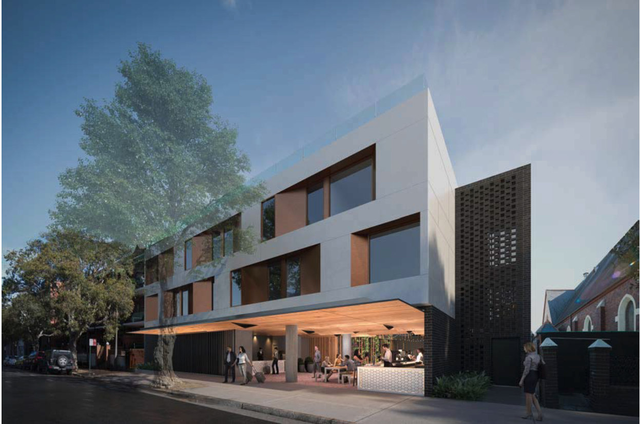
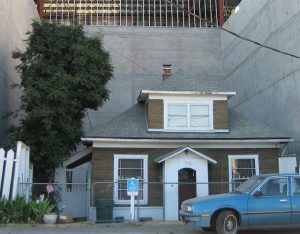
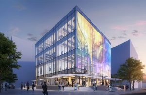
A Development application was submitted to City of Sydney Council on 10thof July 2018 for the construction of a Hotel building at 589-591 Elizabeth Street as shown in the image below. The existing site was a petrol station and vehicle repair centre but is currently vacant. Adjoining the site to the north is an existing local heritage item and the site is located within a heritage conservation area.
The subject site is zoned R3 Medium Density Residential and is adjoined by a small pocket of R4 High Density Residential land to the south.
Zone B4 Mixed Use
• To provide a mixture of compatible land uses.
• To integrate suitable business, office, residential, retail and other development in accessible locations so as to maximise public transport patronage and encourage walking and cycling.
• To ensure uses support the viability of centres.
2 Permitted without consent
Home occupations
3 Permitted with consent
Boarding houses; Centre-based child care facilities; Commercial premises; Community facilities; Educational establishments; Entertainment facilities; Function centres; Hotel or motel accommodation; Information and education facilities; Medical centres; Passenger transport facilities; Recreation facilities (indoor); Registered clubs; Respite day care centres; Restricted premises; Roads; Seniors housing; Shop top housing; Any other development not specified in item 2 or 4
4 Prohibited
Extractive industries; Heavy industrial storage establishments; Heavy industries
The application was lodged
Additional information was requested to address concerns raised from the residents in regards to the retention of the existing trees on Elizabeth Lane as well as the roof top terrace and to provide further setbacks to reduce visual privacy impacts. The applicant revised the development and resubmitted additional information. It is noted however that there was no addendums to any of the reports and the statement of environmental effects was not changed. The revised development appears to have removed the café/restaurant from the site however this is still mentioned in every report. It is requested that all reports be updated to reflect the development that is before council for approval.
The proposed development is located adjacent to the local heritage item known as Church ‘The Where Kakakel’.
The church is described as being constructed between 1888 – 1889 and the physical description is:
Single storey Inter-War Gothic style church. It features high pitched roof with slate cladding, 3 lacent windows on the gable facing the front street, and a side porch on the north. The building is built in face bricks with rendered mouldings on opening edges.
The heritage item is in excellent condition and is one of many heritage items in the locality. The heritage aspect of the area is highly desirable and the development surrounding the item should fit with the development and not be detrimental. The proposed development has not been designed in context to the heritage item and will result in a negative impact on the item and the heritage area. The Heritage Impact Statement provided with the application provides the following statement regarding the design of the building:
“The stepped and setback elements of the built form and large landscaped central courtyard help to reduce the impact on the heritage church and provide a visual curtilage for the heritage item”.
The elevations however show the development being constructed with a zero side boundary setback and will essentially be abutting the church from a visual perspective. The development does not sufficiently provide setbacks to allow a visual curtilage to the heritage item. The development will obscure the item further from the enjoyment of the community.
The development will completely obscure view of the southern elevation of the heritage item and as such will reduce the heritage value of the item.
Additionally, it is not considered that the development used design elements to enhance the heritage item or the heritage conservation area. The surrounding developments in the locality have been designed with similar building designs, materials and are generally in context with the area. Each of the surrounding developments is minor in nature with no single development appearing out of context. The modernistic design and bulk and scale of this development will ensure the hotel stands out and will become the visually dominant building in the locality.
The proposed development is located within a 12m maximum building height area under the LEP and as such the development on site should have a maximum height of 12m. The development submitted to Council shows a non compliance of 2.7m which is a breach of 24.75%. From viewing the Council register for variations to development standards this is a considerable breach where most breaches are under 10%. A variation request under clause 4.6 was provided by the applicant to justify the considerable non compliance.
Assessment against the objectives of the development standard:
Objective:(a) to ensure the height of development is appropriate to the condition of the site and its context,
Applicant:
At a high level – the proposed building successfully mitigates environmental impacts such as overshadowing, privacy and view loss consistent with this objective. The height variation largely arises from the slope of the site (approx. 1.5m) from east to west. The architectural response provides appropriate setbacks, articulation and stepping having regard to the adjoining heritage item and the built form character of the locality.
Comment:
The proposed development has been designed to take full advantage of the site at the detriment to adjoining buildings and particularly the heritage item. While there is a slope to the site it is considered that an better design outcome could have been achieved on the site that complies with the development standard. The height non compliance is made worse due to the visual bulk and scale of the development and the impact the development has on the adjoining land owners. It would also appear that the development plans provided attempt to show the non compliant roof area as non intrusive by colouring it white on the plans in an attempt to hide it from being visually dominant.
Objective:(b) to ensure appropriate height transitions between new development and heritage items and buildings in heritage conservation areas or special character areas,
Applicant:
The relationship of the proposal to proximate heritage items is considered appropriate. Specifically, the architectural solution has carefully considered the adjoining heritage Church at 587 Elizabeth Street in the following ways:
Comment:
It appears from the elevations that the heritage item was a last minute thought when designing the proposed development. There is no consideration to the heritage item and the proposed development will be visually dominant and will be made worse by the non compliant building height.
Objective:(c) to promote the sharing of views,
Applicant:
N/A – the proposal will not impact the sharing of views from the public domain.
Comment:
It is considered that the proposed development will potentially obscure views from the terraces on the eastern side of Elizabeth Street. The potential view loss assessment is not part of this objection letter however it is requested that Council look into whether there is a view loss impact as a result of the development.
The proposed development should be redesigned to comply with the development standard. The third level for the development should be removed with the lift overrun located in place of the five hotel rooms. The reduction in the overall height of the development will go a long way in reducing the impact of the development on the residents and the locality as a whole.
The original submitted GFA Calculations and diagrams were inaccurate with many errors and areas that weren’t calculated as they should have been under the definition.
Additional information was requested and the second set of GFA Diagrams show the development having a gross floor area of 1243.1sqm with the maximum allowable GFA of the site being 1243.2sqm. On assessment of the GFA diagrams it is noted that the calculated area on each level excludes some areas that should be considered to be part of the gross floor area of the building.
Gross floor area is defined as the following:
gross floor area means the sum of the floor area of each floor of a building measured from the internal face of external walls, or from the internal face of walls separating the building from any other building, measured at a height of 1.4 metres above the floor, and includes:
(a) the area of a mezzanine, and
(b) habitable rooms in a basement or an attic, and
(c) any shop, auditorium, cinema, and the like, in a basement or attic,
but excludes:
(d) any area for common vertical circulation, such as lifts and stairs, and
(e) any basement:
(i) storage, and
(ii) vehicular access, loading areas, garbage and services, and
(f) plant rooms, lift towers and other areas used exclusively for mechanical services or ducting, and
(g) car parking to meet any requirements of the consent authority (including access to that car parking), and
(h) any space used for the loading or unloading of goods (including access to it), and
(i) terraces and balconies with outer walls less than 1.4 metres high, and
(j) voids above a floor at the level of a storey or storey above.
The GFA calculations provided with the application does not include the areas located within 2m of the “open corridor” that is located adjacent to the court yard. It is not known why a 2m buffer was provided by the applicant in the GFA Plans other than to reduce the overall GFA of the site in order to comply with the floor space ratio requirements. An independent assessment is proposed by Council to calculate the GFA of the site and where a non-compliance arises a redesign of the development should be provided.
The information provided with this development application did not include a crime risk assessment report. The residents raised deep concerns about the level of risk associated with this development. Elizabeth Lane is already a frequent destination for vandalism, crime and homeless people. The residents of Elizabeth Lane regularly call the local police station in regard to people in the laneway. The proposed development results in several areas of high risk on Elizabeth Lane in regard to crime risk both for the occupants and staff of the hotel and the residents of Elizabeth Lane.
It is considered that a crime risk report should be provided with this application with a detailed assessment of the project against the CPTED principles and mitigation measures to reduce crime risk as a result of the development. Where the principles result in an unacceptable impact on the residents or the patrons of the hotel a redesign of the development should be undertaken.
The proposed development contains large windows on the western elevation of level 2. It is considered that the windows of level 2 of the proposed building will result in substantial visual privacy impacts on the adjoining properties on Elizabeth Lane. As can be seen from the subject site, the terrace houses that back onto Elizabeth Lane contain their main outdoor recreation spaces at the rear of the site.
There are additional privacy concerns relating to the windows on the first storey of the development and on the ground level.
Planning Principle – Privacy Impact
An assessment of the privacy impact is provided against the planning principle Meriton V Sydney City Council [2004] NSWLEC 313 as follows:
In the case of the proposed development, the site is located in a B4 Mixed Use zone with the terrace houses being located within a R1 General Residential zone. The surrounding development on Elizabeth Street that backs onto Elizabeth Lane is sympathetic to the residential zone with the buildings being designed to mitigate visual privacy impacts. As such there is an accepted level of privacy achieved for the residential zone despite fronting a Mixed use B4 Zone.
The proposed development will contain windows oriented to face the upstairs bedrooms of the terrace houses as well as overlooking into the rear entertainment areas. The separation provided is not sufficient in reducing overlooking impacts. The building should be redesigned with further separation on the level 2 windows or removal of the windows, additionally the ground and first floor windows should be redesigned or removed.
As stated above, the proposed development will impact the privacy of the upstairs bedrooms as well as the ground floor private open space. It should be noted that the private open space is the only outdoor recreational area for the terrace houses.
It is considered that the privacy impact occurs through poor design of the hotel. If the hotel was designed to be more sympathetic and of a scale that suited the locality the privacy impact would not be as substantial.
The ground floor private open space is accessed directly off the downstairs living area and is a transitional space used regularly for entertainment. The buildings have been designed for the occupants to enjoy these spaces with adequate privacy. Due to the nature of terrace housing this is the only area for outdoor private open space and as such it is critical to maintain privacy.
The proposed development provides no mitigation measures to reduce privacy.
Landscaping is not used to reduce privacy impacts.
The area along Elizabeth Street is undergoing urban renewal in some areas however the ongoing design theme of these projects is keeping the traditional look of the development and matching the context of the area. The new developments are designed to minimise overlooking impacts. It is therefore considered that, while the area is undergoing change, this change does not warrant unacceptable privacy impacts.
Through approving this development, the council will set a dangerous precedent for bulky, visually dominant buildings that result in substantial impacts on adjoining residences.
The shadow diagrams provided are difficult to read and do not seem to accurately portray the extent of overshadowing as a result of the development. The applicant has not submitted any shadow diagrams of the existing development on site to enable a direct comparison between what the overshadowing is on site and the proposed development.
An assessment of the overshadowing could not be undertaken as a result of the solar access diagrams. Additional information is requested to provide new shadow diagrams to show the extent of the existing overshadowing of the adjoining properties.
Acoustic Privacy is a main concern of the residents adjoining Elizabeth Lane. It is noted that the acoustic report submitted with the development application should be revised as a result of the development changing and should be revised further as a result of any changes resulting from this round of notification. The current report does not address noise impacts on adjoining residential buildings and does not sufficiently provide any mitigation measures for the development to minimise noise. Acoustic considerations should have been implemented into the design at the start of the development rather than relying on a consultant to provide justifications for the location of plant and service areas adjoining a quiet residential lane.
A redesign of the development should be imposed on the applicant to remove the access and waste collection of the site from the rear lane. The applicant shall ensure that all plant and equipment provided with the development are located at the front of the site towards Elizabeth Street to minimise noise impacts on the residences along Elizabeth Lane.
The planning principle, Stockland Developments v Wollongong Council and others [2004] NSWLEC 470deals with noise impacts on sensitives receivers as followed:
As a general planning principle, where there is conflict between a noise source and a sensitive receptor preference should be given to the attenuation of any noise from the source rather than at the sensitive receptor.
As per the planning principle above, any noise mitigation measures should be provided at the source of the noise rather than relying on the sensitive receivers to implement measures to maintain their acoustic privacy. This can easily be achieved through a redesign of the development to remove any noise generating devices from the rear lane to the front of the site.
It is requested that Council undertaken an independent acoustic assessment of the development site with noise logging over a 7 day period with the noise loggers placed on every side of the development site with specific attention to Elizabeth Lane. If Council is unwilling to undertake this to ensure the acoustic privacy of the residents is maintained, then the residents request to be notified of this so that they can engage their own independent acoustic engineer to undertake noise logging to ensure that the noise baseline specified for the development is accurate.
The proposed development is considered to not be compatible with the surrounding development. The Planning Principle, Project Venture Developments Pty Ltd v Pittwater Council 2005, provides a clear assessment path to determine whether a development is compatible with the surrounding development. The Principle establishes the following two questions to be answered to determine whether a proposal is compatible with its context:
An assessment against the planning principle follows:
As mentioned in this assessment, the development has substantial impacts on the surrounding developments with breaches to the height limit, impacts on visual privacy and overshadowing. Additionally, the impact of the development in context of the heritage item is considered unacceptable and as such it is considered that the physical impacts of the development on the surrounding lots is substantial.
This report addresses that the development is out of character of the street and the area due to the bulky size of the development, the height and the design of the development. The proposed development is located within a heritage area and adjoins heritage items. The design of surrounding developments is generally all in context to the area and uses brick facades and generally attempts to match the development with a turn of the century industrial/factory look. The proposed development is considered to be not in accordance with the surrounding development and therefore should be refused.
The proposed development is considered to be out of character for the area and particularly out of character considering the surrounding development. The DCP provides the following locality statement for the area:
This locality is bounded by Cleveland Street to the north, Elizabeth Street to the east, the back of lots fronting Redfern Street to the south and Regent Street to the west. This locality falls within the Sydney Metropolitan Development Authority Operational area.
The diversity of building types and scales that give the neighbourhood its unique character are to be retained. The re-use of older warehouse buildings that add interest to the otherwise residential character is encouraged. The area’s rich heritage including residential and industrial buildings is to be retained.
The intimate scale of small, narrow streets and lanes fronted by narrow lots should be protected to retain its human scale, charm, amenity and heritage values. A diversity and mix of commercial and retail uses along Elizabeth Street to the east of the neighbourhood is encouraged, while retaining the residential component that sustains those uses.
The applicant makes the following statements regarding the locality statement:
The proposal aims to retain the low-density neighbourhood character of the area through the built form, scale and design of the hotel. The primary frontage on Elizabeth Street is partially open, inviting visitors and guests into the development and creating an attractive streetscape presentation. This permeability also reveals the diversity of uses, including the café/bar at the ground level which will activate the street frontage.
The proposed uses align directly with the locality statement for Prince Alfred Park South. The provision of boutique accommodation with an ancillary café will boost the tourism industry in an area lacking visitor accommodation options, supporting the economic growth of the area and broader LGA.
The proposal will retain the diversity of building types, built form and mass in the locality.
The demolition of the existing dilapidated building, identified as ‘detracting’ from the Heritage Conservation Area, will restore the character and amenity of the area. The values of the surrounding heritage items of local significance and the Conservation Area has been considered in the design of the development to achieve a sympathetic response to the surrounding area. Refer to the Heritage Impact Statement at Appendix O.
The proposed development has been designed with a generic design that is not sympathetic to the surrounding locality. The site adjoins a heritage item and is located within the heritage conservation area. The building has a modern design that will be visually dominant compared to the surrounding buildings. The applicant relies on the fact that the existing development is a service station that is in a dilapidated state that detracts from the Heritage Conservation Area. The DCP Control 3.9.9 Detracting buildingsprovides guidance for building that a detracting to the heritage conservation area as follows:
Detracting buildings are buildings that are intrusive to a heritage conservation area because of inappropriate scale, bulk, setbacks, setting, design or materials. They do not represent a key period of significance and detract from the character of a heritage conservation area.
There is no argument that the existing building is not a detracting building for the locality, however given the scale of the building, it is not visually dominant and helps to provide visual access to the heritage item from the public domain as well as resulting in a sense of open space within the street frontage. The proposed development, however, will obscure the heritage item further from view and as mentioned will be visually dominant within the streetscape.
The original submitted plans provided a roof top terrace on the third storey with a connecting gym. The applicant has since removed the roof top terrace, but it is noted that the space is still provided on the plans with doors and stairs leading out from the area immediately adjoining the hotel rooms. The roof top area is noted on the plans as being not accessible for hotel guests but the access to the area is not obscured from hotel guests and instead is easily accessible. Concern is raised that the area will be set up as a roof top terrace despite the plans showing it being removed and that future retrospective approval of the area as a roof top terrace would occur.
To prevent access to the roof from hotel guests, the roof area should be redesigned to only provide access through a service area rather than through the lift lobby. This would prevent unauthorised use of the roof top area and ensure that the privacy and amenity of the adjoining residents is maintained for the life of the development.
The proposed development is a hotel that provides 58 rooms for guests and under the DCP requirements is required to provide the following, at a minimum:
The proposed development provides 14 carparking spaces located in the basement area. The carparking spaces are only accessible via a car lift as part of a valet system. The applicant explains the reason for using a mechanical car lift is due to the site being too small to provide a vehicular access ramp. The site provides no service vehicle parking and no on-site passenger pick up and set down area. Additionally, the site does not provide an adequate location for bus/coach parking.
As mentioned, the proposed development provides a mechanical car lift system to gain access to the basement parking. The applicant intends the patron of the hotel to pull up along Elizabeth street and hand the vehicle over to a valet who would drive the car around to the back of the site via Elizabeth Land and park the car in the basement. It is noted that the valet service is provided in the public domain rather than onsite.
In regards to the passenger set down and pick up not being provided on site, the applicant provides the following response:
Due to site constraints, it is not possible to accommodate two parking spaces at grade for passenger pick-up and set-down.
To accommodate the proposed valet service and passenger pick up and set down, it is proposed that two on-street bays on Elizabeth Street are converted to 15-minute parking bays.
The site is considered to be a large site that currently contains ample space for at grade parking. The statement should read “due to the design of the development, it is not possible to accommodate two parking spaces at grade for passenger pick-up and set-down”. The applicant cannot rely on their own design short comings to allow deficient parking as required under the DCP.
In regards to mechanical parking installations, the DCP provides the following:
Mechanical parking installations will be considered for developments involving the adaptive re-use of existing buildings where site or building constraints prevent standard parking arrangements and no inconvenience arises from their use.
The applicant provided the following response:
This is considered an appropriate solution due to the nature of the site on a small lot, unable to accommodate a vehicular access ramp. The proposed solution enables parking on the site without impacting the surrounding road network or servicing requirements. As discussed in the Traffic Assessment at Appendix G, the car lift and basement car park meets the relevant Australian Standards AS2890.1 and swept path requirements.
From a design perspective it would appear that the reasons behind the lack of a vehicular access ramp and the use of a mechanical lift system is to reduce the cost of construction and to provide a larger street presence and rely on the inadequate, narrow rear lane access to hide the parking and services. Where the site is truly too small to accommodate a vehicular access ramp, a letter signed by a suitably qualified engineer should be provided that states that there is no ability for the site to provide a vehicular access ramp.
It is considered, from general viewing, that an access ramp and vehicular set down/pick up area could be provided fronting Elizabeth street to the north side of the development immediately adjoining the heritage item. Architectural features could be provided to this access and it would provide a visual separation between the existing heritage item and the proposed development. The redesign to place the driveway fronting Elizabeth street will result in a better, complying design outcome for the applicant as well as the wider community.
Additionally, service vehicles would be able to enter the site via the access to drop off and pick up items relating to the development. No access should be provided to the site from Elizabeth Lane due to the narrow nature of the lane and the impact the access would have on the adjoining neighbours. The site is large enough to provide all access off Elizabeth Street including access for waste collection.
The residents have strong concerns regarding the traffic impact assessment that was submitted with the application and the assessment of traffic and parking. Of particular concern is the assessment of the traffic within Elizabeth Lane as being negligible. While the traffic in the lane is minor compared to other street it is considered that the traffic is considerably heavy due to the size and width of the street. The lane is a thoroughfare that is used by commuters as a shortcut to avoid traffic.
The residents have deep concerns regarding the development accessing the site via Elizabeth Lane. The residents have complained to Council several times in regard to vehicles being double parked in the street for days on end and the dangerous nature of the lane. The lane is extremely narrow and is currently a two-way street. The residents adjoining Elizabeth Lane have deep concerns regarding garbage pick up being provided in the rear lane as the lane is already congested with garbage bings during pick up periods. It is considered that the addition of bins for the hotel will be a detrimental impact to the street and there is no reason the bins could not be collected at the front of the site.
The development should be redesigned further to provide access from Elizabeth Street and remove the rear access mechanical parking lift from Elizabeth Lane. The redesign should include an access ramp that allows for passenger drop off and pick up and the ability for service vehicles to access the site. The development should not rely on street parking to comply with the parking requirements as this is not an acceptable solution for the site.
The proposed development is located on a site that was previously a service station with underground fuel tanks. A contamination report was provided with the documents submitted with the application however the report does not address the concerns of the residents. It is recommended that an independent assessment be conducted by Council to assess the level of contamination on site considering the age of the service station.
Additionally, it is recommended that Council request the application to provide a contamination report by a suitably qualified professional with clear outlines of the contamination and remediation methods that will be required on the site. The contamination report should contain geotechnical investigation of the soil to determine heavy metal levels and other dangerous elements. The report should be prepared in accordance with the NSW Guidelines.
The development application, as it stands at the moment, is confusing and missing valuable information to make an informed assessment of the application. Based on the review of the information that has been submitted it is the writers opinion that the design of the development should be amended to reflect the site constraints.
It is recommended that Council request the applicant to revise the application in the following ways to address the issues with the design and the impact on adjoining properties and the wider community:
It is noted that the residents are not against development and are wanting a good design outcome that will not impact their amenity and safety. The above recommendations should requested as a minimum however considering the extensive list of redesigns and reports it would be a better outcome for the applicant to withdraw the application to enable the proper revision of the application and resubmitted as a fresh application that achieves compliance and has a positive impact on the community.


A REF (review of environmental factors) is a document prepared by a consultant and submitted to the relevant consent authority.

We look at the the ins and outs of obtaining an approval for Sex Services (Brothel) within NSW and what you need to consider with a site and application.

We look at the processing time for statement of environmental effects and the process we take!
The statement of environmental effects is a document that most people are confused by. We offer advice on how to write a good quality statement of environmental effects!
We now offer template statement of environmental effects for development applications so you can fill out your own report based on your development. Buy our template statement of environmental effects report.

Building Designers! Outsource your statement of environmental effects to Outlook Planning and Development and save time and money! Let us deal with the report so you can focus on the plans!
Beresfield is one of the biggest hot spots within the Newcastle area with investors and first home buyers flocking to the area to score great prices for great blocks of land. We look at what to look for for development within the area and how to maximise on your investments including dual occupancies and subdivisions.
Unapproved works is one of our most common jobs for Outlook Planning and Development. Read our article on what to do and how to deal with the scary letters from Council!

We explain what to consider when planning a rural subdivision and the various costs and reports associated.

Thornton and Chisholm has become a booming area for investors and first home buyers wanting to leave Sydney and head towards the Hunter Valley. The greater Maitland area is a booming area with plenty of land available for developers.
We explain what types of development you can do without any Council approval for everyone doing their home renovations. Read all about exempt development and what you can build this weekend after a trip to Bunnings to get your DIY tools.

Want to build a house or renovate but don’t want the hassle of a development application. You might be able to get approval through a private certifier. We take some time to explain what a complying development is and the steps you need to take to obtain a CDC through a private certifier.

Heritage Impact Statements are essential for any development involving a heritage item or heritage conservation area. We go into some of the basics of what makes up a heritage impact statement and who should be preparing them for your development.
Council Das can cause a lot of stress! Have you received a notification in the mail about a development application and want to write a submission. We outline some steps to help you prepare a development application objection letter.

The first concept designs for Western Sydney Airport Terminal have been unveiled.
New generation boarding houses have a lot of negativity at the moment with developers obtaining approvals for large scale boarding house developments. So what exactly is a new generation boarding house?
Northern Beaches Town Planners explain Dual occupancy facts on the Northern Beaches including Pittwater, Warringah and Manly. We provide some information on dual occupancy developments on the Northern Beaches of Sydney. Where you should be looking and what you should be considering.

We explore the theory that as the amount of parking decreases, the appeal of driving gives way to more environmentally friendly transport modes such as walking, cycling, ride-hailing, car pooling and public transport.
Some evidence suggests reducing or capping parking pays off. In cities that have implemented these measures, driving has declined and public transport use has increased.
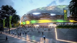
The redevelopment of the Sydney Football Stadium has been full of controversy with a massive public backlash to the development.
The development has been subject to a lot of public debate with questions as to why the NSW Government are demolishing a functioning stadium instead of upgrading the stadium at a fraction of the cost.
The University of Newcastle has recently submitted a seven building masterplan to the NSW Government for their new education precinct for Honeysuckle in Newcastle.
A REF (review of environmental factors) is a document prepared by a consultant and submitted to the relevant consent authority.
We look at the the ins and outs of obtaining an approval for Sex Services (Brothel) within NSW and what you need to consider with a site and application.
The statement of environmental effects is a document that most people are confused by. We offer advice on how to write a good quality statement of environmental effects!
We now offer template statement of environmental effects for development applications so you can fill out your own report based on your development. Buy our template statement of environmental effects report.
Building Designers! Outsource your statement of environmental effects to Outlook Planning and Development and save time and money! Let us deal with the report so you can focus on the plans!
Beresfield is one of the biggest hot spots within the Newcastle area with investors and first home buyers flocking to the area to score great prices for great blocks of land. We look at what to look for for development within the area and how to maximise on your investments including dual occupancies and subdivisions.
Unapproved works is one of our most common jobs for Outlook Planning and Development. Read our article on what to do and how to deal with the scary letters from Council!
We explain what to consider when planning a rural subdivision and the various costs and reports associated.
Thornton and Chisholm has become a booming area for investors and first home buyers wanting to leave Sydney and head towards the Hunter Valley. The greater Maitland area is a booming area with plenty of land available for developers.
We explain what types of development you can do without any Council approval for everyone doing their home renovations. Read all about exempt development and what you can build this weekend after a trip to Bunnings to get your DIY tools.
Want to build a house or renovate but don’t want the hassle of a development application. You might be able to get approval through a private certifier. We take some time to explain what a complying development is and the steps you need to take to obtain a CDC through a private certifier.
Heritage Impact Statements are essential for any development involving a heritage item or heritage conservation area. We go into some of the basics of what makes up a heritage impact statement and who should be preparing them for your development.
Council Das can cause a lot of stress! Have you received a notification in the mail about a development application and want to write a submission. We outline some steps to help you prepare a development application objection letter.
The first concept designs for Western Sydney Airport Terminal have been unveiled.
New generation boarding houses have a lot of negativity at the moment with developers obtaining approvals for large scale boarding house developments. So what exactly is a new generation boarding house?
Northern Beaches Town Planners explain Dual occupancy facts on the Northern Beaches including Pittwater, Warringah and Manly. We provide some information on dual occupancy developments on the Northern Beaches of Sydney. Where you should be looking and what you should be considering.
We explore the theory that as the amount of parking decreases, the appeal of driving gives way to more environmentally friendly transport modes such as walking, cycling, ride-hailing, car pooling and public transport.
Some evidence suggests reducing or capping parking pays off. In cities that have implemented these measures, driving has declined and public transport use has increased.
The redevelopment of the Sydney Football Stadium has been full of controversy with a massive public backlash to the development.
The development has been subject to a lot of public debate with questions as to why the NSW Government are demolishing a functioning stadium instead of upgrading the stadium at a fraction of the cost.
The University of Newcastle has recently submitted a seven building masterplan to the NSW Government for their new education precinct for Honeysuckle in Newcastle.
Outlook Planning and Development were engaged by a group of concerned residents in regards to a nearby development that sought consent to demolish an existing (abandoned) service station to a boutique hotel with 58 guest rooms, car lift and guest facilities.
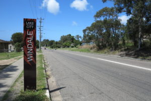
A change of land zoning proposed by Lake Macquarie council would open the door for medium-density housing in a large part of Windale.

Granny flats, or secondary dwellings as they are known as in the Planning world, can allow home owners to keep parents or adult children close by while giving them their own space. They can also be a great way to generate additional rental income.

Newcastle and the Hunter Valley has become a hot spot for developers as well as residents of Sydney looking for a tree change and a work life balance. There is so much development potential and lots of great properties within the area for a fraction of the price of Sydney.
We look at the five things to consider before buying a block of land! Is it better to buy established or purchase a vacant lot and building?
We look at the processing time for statement of environmental effects and the process we take!